California’s December Inferno

Southern California continues to burn


In Southern California, wildfires continue to burn. It is rare for large wildfires to burn in California in December, which is usually a wet month for the state. In most years, a few hundreds acres might burn. The 2006 Shekell fire in Ventura charred 13,600 acres, making it the largest December fire in the state between 2000 and 2016.

California’s December Inferno

In 2017, the Thomas fire shattered the record for December and may soon eclipse the worst blaze in any month. After burning for 16 days, the massive fire had scorched 272,000 acres (110,000 hectares or 425 square miles) and was just 60 percent contained. That made it the second largest fire on record in California, trailing only the Cedar fire, which burned 273,246 acres in 2003.

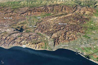
The Operational Land Imager (OLI) on Landsat 8 captured an image of the Thomas fire scar on December 18, 2017. The natural-color Landsat 8 image was draped over an ASTER-derived Global Digital Elevation Model, which shows the topography of the area. The fire raged first near Ventura, then burned the hills around communities of Ojai and Oak View. Firefighters put up a fierce fight and managed to prevent flames from descending into the valley towns. Flames then pushed west toward Summerland, Montecito, and Santa Barbara. As of December 20, the fire was still spreading along the northern edge of the burn scar.

Authorities reported that more than 1,200 structures—most of them in Ventura County—have been destroyed. Several factors came together to make the blaze difficult to control. An usually wet winter and spring in early 2017 caused vegetation to flourish. Then the dry season turned out to be excessively dry, and rains also have been scarce in the typically wetter months of November and December. All of that vegetation dried out and was primed to burn. Once the fire started, warm temperatures and unusually fierce Santa Ana winds caused the fire to spread rapidly.

After nearly two weeks of red flag conditions, a break in the weather has allowed firefighters to beat back the flames in the past few days. But fire officials still do not expect the Thomas fire to be completely contained until January 2018.

On December 14, 2017, the Visible Infrared Imaging Radiometer Suite (VIIRS) (VIIRS) on the Suomi NPP satellite acquired a natural-color image of smoke billowing from the Thomas Fire in Ventura and Santa Barbara counties. By December 15, the fire had charred 252,500 acres (102,200 hectares or 400 square miles). That made it the fourth largest fire in California history.

High-resolution climate models present alarming new projections for US

High-resolution climate models present alarming new projections for US


Approaching the second half of the century, the United States is likely to experience increases in the number of days with extreme heat, the frequency and duration of heat waves, and the length of the growing season. In response, it is anticipated that agricultural and ecological needs will increase the demand on already-strained natural resources like water and energy. University of Illinois researchers have developed new, high-resolution climate models that may help policymakers mitigate these effects at a local level.

In a paper published in the journal Earth's Future, atmospheric sciences professor Donald Wuebbles, graduate student Zach Zobel and Argonne National Laboratory scientists Jiali Wang and Rao Kotamarthi demonstrate how increased-resolution modeling can improve future climate projections.

Many climate models use a spatial resolution of hundreds of kilometers. This approach is suitable for global-scale models that run for centuries into the future, but they fail to capture small-scale land and weather features that influence local atmospheric events, the researchers said.

"Our new models work at a spatial resolution of 12 km, allowing us to examine localized changes in the climate system across the continental U.S.," Wuebbles said. "It is the difference between being able to resolve something as small as Champaign County versus the entire state of Illinois -- it's a big improvement."

The study looked at two different future greenhouse gas output projections -- one "business as usual" scenario where fossil fuel consumption remains on its current trajectory and one that implies a significant reduction in consumption by the end of the century. The group generated data for two decade-long projections (2045-54 and 2085-94) and compared them with historical data (1995-2004) for context.

"One of the most alarming findings in our business-as-usual projection shows that by late-century the southeastern U.S. will experience maximum summer temperatures every other day that used to occur only once every 20 days," Zobel said.

Although not as severe, other regions of the country are also expected to experience significant changes in temperature.

"The Midwest could see large unusual heat events, like the 1995 Chicago heat wave, which killed more than 800 people, become more common and perhaps even occur as many as five times per year by the end of the century," Wuebbles said. "Heat waves increase the mortality rate within the Midwest and the Northeast because people in these densely populated regions are not accustomed to coping with that kind of heat that frequently."

The extreme temperatures and extended duration of the warmer season will likely take a significant toll on crops and the ecosystem, the researchers said. Areas like the American West, which is already grappling for limited water resources, could witness much shorter frost seasons at high elevations, leading to a smaller surge in spring meltwater than what is needed for the early growing season.

"The high resolution of our models can capture regional climate variables caused by local landforms like mountains, valleys and bodies of water," Zobel said. "That will allow policymakers to tailor response actions in a very localized way."

The new models concentrate on temperature and do not factor in the effect that regional precipitation patterns will have on the impact of the anticipated climate changes. The researchers plan to extend their study to account for these additional variables.

"The concept of global climate change can be somewhat abstract, and people want to know how these projected changes are going to affect them, in their community," Wuebbles said. "Our models are helping answer those questions, and that is what separates our work from the larger, global-scale studies."

Story Source: provided by University of Illinois at Urbana-Champaign. 
Original written by Lois Yoksoulian. 
Note: Content may be edited for style and length.