Climate change in the 21st Century

Climate change in the 21st Century


The Deniers

It is often claimed by those who deny the reality of climate change that scientific forecasts about the impact of global warming are far too uncertain to merit taking action. There is no reason to suffer the inconvenience of leaving the planet's fossil fuels unburned when the current analyses of meteorologists, oceanographers and geophysicists will probably turn out to be false alarms, they argue.

Such contention is dangerously false. For a start, scientists' warnings about future weather patterns are certainly not overreactions to the evidence they have gathered. In most cases, observed climate changes – the slump in summer sea ice coverage in the Arctic in recent years is a good example – have turned out to be far more drastic than researchers had originally predicted. Their views of the future – melting icecaps, spreading deserts and acidifying oceans – are cautious evaluations that most probably underestimate the likely impact of global warming.


Miami

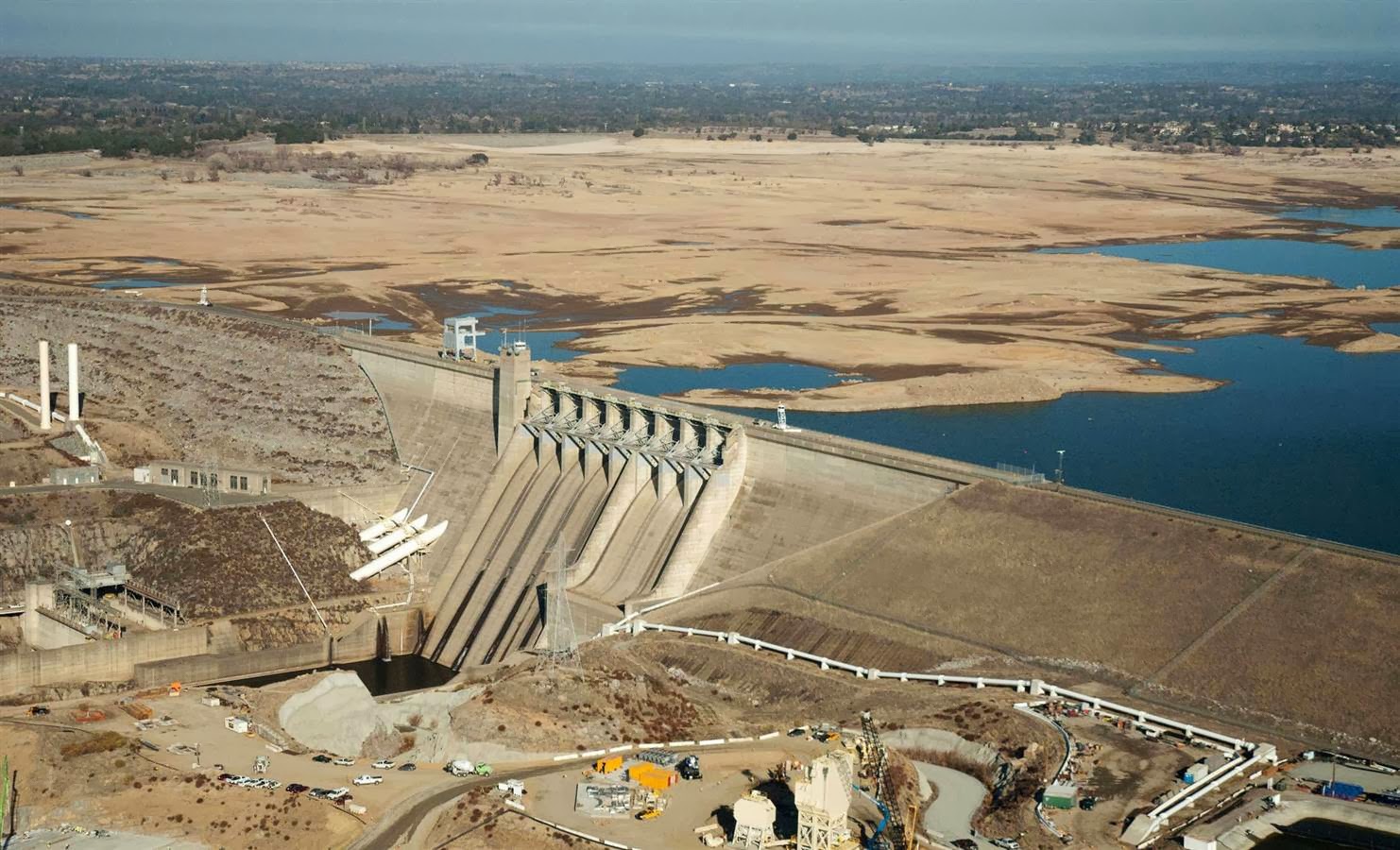
Miami is built on top of porous limestone and its foundations are now absorbing water from rising seas at an alarming rate. Water now bubbles up through pipes and drains and taints fresh water supplies while seawater regularly flows out of drains into streets, which become flooded. Civil engineers currently estimate that the cost of upgrading the drainage systems in Miami would cost billions of dollars and that, please note, is the price that a single city will have to pay to deal with just one aspect of global warming. Repeat it across the globe and you get a notion of the vast cost we now face for having failed to deal with climate change for the past two decades and for faltering in our commitment to agree to curb emissions of carbon dioxide from our factories, power plants and cars.

The result of this continued inaction has been straightforward: climate change – once a far-off threat – is now upon us and is already bringing alarming change to our planet, as the citizens of Miami are now experiencing, along with those living near spreading deserts in Africa, in the far north where tundras are melting, and in high mountain areas in the Andes and Himalayas whose glaciers are now disappearing. As Leonard Berry, director of the Florida Centre for Environmental Studies at Florida Atlantic University puts it: "Climate change is not a future thing, it's a 'happening now' thing." It is a reality that has already arrived and is destined to have increasingly profound impacts until we wake up to the threat and act coherently.
A woman on a moped navigates a flooded street corner on Miami Beach, an all-too-familiar sign for residents of this iconic peninsula where the ocean seems more likely than ever to swamp Ocean Drive one day.

If there's an image that starkly illustrates the threats of climate change, it's this photograph, which was included in the recent National Climate Assessment released by the White House. It is noteworthy because the flood is from exceptionally high spring tides – not heavy rains. Tidal flooding like that is relatively new. And scary. "People in Miami Beach are living climate change," said David Nolan, a meteorology and physical oceanography professor at the University of Miami. "They're on the frontline."

The people of Miami Beach didn't need the National Climate Assessment to tell them low-lying south Florida is "exceptionally vulnerable to sea level rise". The city is already spending $206m to overhaul its drainage system.

The day after the White House released its climate change report, Miami-Dade County's commission passed a 6 May resolution that calls on planners to account for sea level rise. Local officials across the four counties of south Florida are making similar moves. Almost anyone who lives in south Florida has a nagging fear about climate change. It's both abstract and, at times, very real.

One of the most vulnerable places in South Florida: Key West. Homes were flooded by hurricane Wilma in 2005. It was the first flood of its kind and Wilma was the last of an unprecedented eight hurricanes that damaged parts of Florida in 13 months. Talk of global warming mounted after those back-to-back mean seasons. No hurricanes have directly hit since. Widespread discussion about climate change subsided.

Here's what hasn't gone away: rising home insurance rates, which have increased in part because insurance firms do believe in climate change. And then there's the concern that the one investment that we see as the fulfilment of the American dream – our homes – will be impossible to keep or will be so devalued in 30 years that they won't be worth passing on to our children.

Sea level rise threatens our drinking water supplies, farm fields and the main driver of tourism: beaches. But in the absence of a disaster, it's easy for many of us to forget about the long-term risks until a report such as the National Climate Assessment details them. But while local officials are talking about solutions and planning, politicians farther away from south Florida aren't. The issue has become an ideological fault line on the state and national levels. In the state capital in Tallahassee, Republican governor Rick Scott stalled efforts to grapple with the issue.

In Washington, Republican senator Marco Rubio is emerging as a leading sceptic of man-made climate change. A potential 2016 candidate for president, he said that scientists sometimes get it wrong. "Some of these people were predicting a new ice age in the 1970s. Imagine if we had acted on that."

In the Democratic-leaning Miami area, people are not inclined to side with Rubio. But many hope that he's right. Hope does nothing to stop the seas from rising. "Climate change is real," said Nolan. "It's here." And it's clear to anyone walking around South Beach when there's high spring tide.

Antarctica

There is another, more straightforward reason to repudiate deniers' claims about scientists' "false alarms", however. The impact of climate change is not an issue that is going to be determined in far-off years for the simple reason that it is already happening. This is a point made clear by Nasa glaciologist Eric Rignot who reveals that his observations show that a large part of the West Antarctica ice sheet has now begun to disintegrate and that the entire sheet appears today to be in irreversible retreat.

"One of the feared tipping points of the climate system appears to have been crossed," says Stefan Rahmstorf, an expert on the physics of the ocean at Potsdam University. Certainly the consequences of this massive destabilisation of ice cover at the south pole are going to be considerable, scientists now argue

The last assessment report of the Intergovernmental Panel on Climate Change (IPCC) put a modest figure of one to three feet as the likely rise in sea levels that will be experienced this century. The disintegration of the entire West Antarctic ice shelf extends that forecast drastically. A figure of 10 feet is now a more than likely option over the coming centuries. Vast tracts of heavily populated coastline around the world face inundation. Millions are likely to lose their homes. It may take more than a century for this devastation to occur. Nevertheless, it now looks to be inevitable, says Rignot. Nor will the residents of low-lying regions such as Bangladesh or Florida be surprised at this forecast. They are already experiencing the consequences of rising sea levels triggered by melting icecaps.
Last Monday, we hosted a Nasa conference on the state of the West Antarctic ice sheet, which, it could be said, provoked something of a reaction. "This Is What a Holy Shit Moment for Global Warming Looks Like," ran a headline in Mother Jones magazine.

We announced that we had collected enough observations to conclude that the retreat of ice in the Amundsen sea sector of West Antarctica was unstoppable, with major consequences – it will mean that sea levels will rise one metre worldwide. What's more, its disappearance will likely trigger the collapse of the rest of the West Antarctic ice sheet, which comes with a sea level rise of between three and five metres. Such an event will displace millions of people worldwide.

Two centuries – if that is what it takes – may seem like a long time, but there is no red button to stop this process. Reversing the climate system to what it was in the 1970s seems unlikely; we can barely get a grip on emissions that have tripled since the Kyoto protocol, which was designed to hit reduction targets. Slowing down climate warming remains a good idea, however – the Antarctic system will at least take longer to get to this point.

The Amundsen sea sector is almost as big as France. Six glaciers drain it. The two largest ones are Pine Island glacier (30km wide) and Thwaites glacier (100km wide). They stretch over 500km.

Many impressive scientists have gone before us in this territory. The concept of West Antarctic instability goes back to the 1970s following surveys by Charles Bentley in the 1960s that revealed an ice sheet resting on a bed grounded well below sea level and deepening inland. Hans Weertman had shown in 1974 that a marine-based ice sheet resting on a retrograde bed was unstable. Robert Thomas extended his work to pursue the instability hypothesis. Terry Hughes suggested that the Pine Island sector of West Antarctica was its weak underbelly and that its retreat would collapse the West Antarctic ice sheet. Considerable uncertainty remained about the timescale, however, due to a lack of observation of this very remote area.

Things changed with the launch of the ERS-1 satellite which allowed glaciers in this part of antartica to be observed from space. In 1997, I found that the grounding line (where the glacier detaches from its bed and becomes afloat) of Pine Island glacier had retreated five kilometres in the space of four years, between 1992 and 1996. Stan Jacobs and Adrian Jenkins had found a year earlier that the glacier was bathing in unusually warm waters, which suggested the ocean had a major influence on the glacier. Duncan Wingham and others showed that the glacier was thinning. In 2001, I found that Thwaites glacier was retreating too .

At that point, the scientific community took a different look at the region. Work by the British Antarctic Survey, Nasa and Chile led to more detailed observations, a monitoring programme was initiated, instruments were placed on the ice, in the ocean and scientific results started to pile up from a variety of research programmes. From that point, we all sought to find out whether this was really happening. Now, two decades after this process started, we have witnessed glacier grounding lines retreat by kilometres every year, glaciers thinning by metres every year hundreds of kilometres inland, losing billions of tons of water annually, and speeding up several percent every year to the flanks of topographic divides.

Thwaites glacier started to accelerate after 2006 and in 2011 we detected a huge retreat of the glacier grounding lines since 2000. Detailed reconstructions of the glacier bed further confirmed that no mountain or hill in the back of these glaciers could act as a barrier and hold them up; and 40 years of glacier flow evolution showed that the speed-up was a long story.

All these results indicate a progressive collapse of this area. At the current rate, a large fraction of the basin will be gone in 200 years, but recent modelling studies indicate that the retreat rate will increase in the future. How did this happen? A clue is that all the glaciers reacted at the same time, which suggested a common force that can only be the ocean. Ocean heat is pushed by the westerly winds and the westerlies have changed around Antarctica in response to climate warming and the depletion of the ozone. The stronger winds are caused by a world warming faster than a cooling Antarctica. Stronger westerlies push more subsurface warm waters poleward to melt the glaciers, and push surface waters northward.

Nerilie Abram and others have just confirmed that the westerlies are stronger now than at any other time in the past 1,000 years and their strengthening has been particularly prominent since the 1970s as a result of human-induced climate warming. Model predictions also show that the trend will continue in a warming climate.

What this means is that we may be ultimately responsible for triggering the fast retreat of West Antarctica. This part of the continent was likely to retreat anyway, but we probably pushed it there faster. It remains difficult to put a timescale on it, because the computer models are not good enough yet, but it could be within a couple of centuries, as I noted. There is also a bigger picture than West Antarctica. The Amundsen sea sector is not the only vulnerable part of the continent. East Antarctica includes marine-based sectors that hold more ice. One of them, Totten glacier, holds the equivalent of seven metres of global sea level.

Controlling climate warming may ultimately make a difference not only about how fast West Antarctic ice will melt to sea, but also whether other parts of Antarctica will take their turn. Several "candidates" are lined up, and we seem to have figured a way to push them out of equilibrium even before warming of air temperature is strong enough to melt snow and ice at the surface.

Unabated climate warming of several degrees over the next century is likely to speed up the collapse of West Antarctica, but it could also trigger irreversible retreat of marine-based sectors of East Antarctica. Whether we should do something about it is simply a matter of common sense. And the time to act is now; Antarctica is not waiting for us.

Eric Rignot is a glaciologist at NASA's Jet Propulsion Laboratory. He is the lead author of last week's landmark scientific paper on West Antartica

East Antarctic Ice sheet more vulnerable than we thought.


The East Antarctic Ice sheet is more vulnerable than we thought.

Researchers in Germany have found the East Antarctic ice sheet may be less stable than anyone had realized.

Two scientists from the Potsdam Institute for Climate Impact Research say the melting of ice on the East Antarctic shore could ultimately trigger a discharge into the ocean which would result in unstoppable sea-level rise for thousands of years . The Wilkes Basin in East Antarctica, stretching more than 1,000 km (600 miles) inland, has enough ice to raise sea levels by 10-13 feet  if it were to melt. The Wilkes Basin is vulnerable because it is held in place by a small rim of ice, resting on bedrock below sea level by the coast of the frozen continent. That "ice plug" might melt away in coming centuries if ocean waters warm up.

"East Antarctica's Wilkes Basin is like a bottle on a slant," said Matthias Mengel of the Potsdam Institute for Climate Impact Research. "Once uncorked, it empties out."

Co-author Anders Levermann, also at Potsdam in Germany, told Reuters the main finding was that the ice flow would be irreversible, if set in motion. He said there was still time to limit warming to levels to keep the ice plug in place. Almost 200 governments have promised to work out a U.N. deal by the end of 2015 to curb increasing emissions of man-made greenhouse gases that a U.N. panel says will cause more droughts, heatwaves, downpours and rising sea levels.

Worries about rising seas that could swamp low-lying areas from Shanghai to Florida focus most on ice in Greenland and West Antarctica, as well as smaller amounts of ice in mountain ranges from the Himalayas to the Andes. Sunday's study is among the first to gauge risks in East Antarctica, the largest volume of ice of the continent and usually considered stable. "I would not be surprised if this is more vulnerable than West Antarctica. If half of that ice loss occurred in the ice-cork region, then the discharge would begin. We have probably overestimated the stability of East Antarctica so far," said co-author Anders Levermann.

A rim of ice currently holds back the largest region of marine ice on rocky ground in East Antarctica. 
Warming oceans could lead to loss of ice on the coast, while the air over Antarctica stays cold, the researchers say.  If this rim is lost it could trigger sea-level rise of 300-400 centimeters (about 10-13 feet) the researchers report. Sea level rise from Antarctica is projected to increase by 16 centimeters this century.

Computer simulations of the region show it would take 5,000-10,000 years for the basin to discharge completely.  But once started the basin would empty, even if global warming was halted. Their findings, which they say amount to the discovery of a hitherto overlooked source of sea level rise, appear unlikely to happen any time soon. They are based on computer simulations of the Antarctic ice flow using improved data of the ground profile beneath the ice sheet.

Antarctica’s Pine Island Glacier B31 calving on NASA video.

Antarctica’s Pine Island Glacier is captured by NASA video melting before our eyes, releases massive amounts of ice, one measuring 12×24 miles in size (nearly 290 square miles), and many others in a large flotilla of icebergs.

An iceberg called "B31" began its journey out into the Southern Ocean. It is just the most recent event in the now ongoing decline of the Pine Island Glacier. And we can expect many, many more major ice releases as this vast glacier continues its deglaciation.
"Iceberg calving is a very normal process. However, the detachment rift, or crack, that created this iceberg was well upstream of the 30-year average calving front of Pine Island Glacier (PIG), so this a region that warrants monitoring." said Kelly Brunt, a glaciologist at NASA’s Goddard Space Flight Center.


The Antarctic ice sheet is the largest mass of ice on earth, containing the equivalent to 190 ft. of sea level rise. The Pine Island and Thwaites glaciers are two of Antarctica's five largest ice streams. Scientists have found that the flow of these ice streams has accelerated in recent years. If they were to melt, global sea levels would rise by 3 to 6 ft and would risk destabilising the entire West Antarctic Ice Sheet.

About 14 years ago, another large ice mass called "B15" calved from Antarctica. Iceberg B-15 is the world's largest recorded iceberg. It measured around 183 miles long and 23 miles wide, and calved from the Ross Ice Shelf of Antarctica in March 2000. The video below will give you an idea of the size of these.


In March 2000, Iceberg B-15 calved from the Ross Ice Shelf near Roosevelt Island, Antarctica. The calving occurred along cracks in the ice shelf, similar to what happened to B31.

Extreme Weather - April 2014


Mother Nature is a deadly force. From Cyclones to Tornadoes, Lightning to Snow, these are a few events that have taken place over the past week or so.

NASA scientists react to 400 ppm carbon milestone


CO2, better known as carbon dioxide, hit 402 parts per million this week. That is the highest level recorded in at least 800,000 years. The recordings came from the National Oceanic and Atmospheric Association’s Mauna Loa Observatory in Hawaii, which marked another ominous milestone last May when the 400 ppm threshold was crossed for the first time in recorded history. Since 1958, the Mauna Loa Observatory has been gathering data on how much carbon dioxide is in the atmosphere. CO2 is the greenhouse gas that drives climate change, and carbon dioxide has increased by 24 percent since 1958.

The Mauna Loa Observatory CO2 monitoring station is recording CO2 concentrations above 400 parts per million . These are the highest levels found on earth in millions of years. The last time CO2 levels at Mauna Loa were this high, human beings did not live on this planet. The last time CO2 levels were this high was during an era known as the Pliocene, more than 2.5 million years ago. The Arctic grew lush forests instead of ice and snow. The planet's temperature averaged about 5-6 degrees F warmer, and sea levels were 15 feet higher.

We are seeing the effects of climate change in the form of rising seas, wildfires, droughts, and extreme weather of all kinds. Passing the 400 PPM mark is an ominous sign of what might come. While the level only goes up year after year, this is a sign that our dependence on fossil fuels is out of control. The  only way to get to a safe level of carbon dioxide is to immediately transition away from fossil fuels.

NASA rounded up a few scientists here and asked them what passing 400 ppm means to them.

Passing the 400 mark reminds me that we are on an inexorable march to 450 ppm and much higher levels. These were the targets for 'stabilization' suggested not too long ago. The world is quickening the rate of accumulation of CO2, and has shown no signs of slowing this down. It should be a psychological tripwire for everyone.
– Dr. Michael Gunson
Global Change & Energy Program Manager; Project Scientist,
Orbiting Carbon Observatory-2 satellite mission - NASA Jet Propulsion Laboratory

CO2 concentrations haven't been this high in millions of years. Even more alarming is the rate of increase in the last five decades and the fact that CO2 stays in the atmosphere for hundreds or thousands of years. This milestone is a wake up call that our actions in response to climate change need to match the persistent rise in CO2. Climate change is a threat to life on Earth and we can no longer afford to be spectators.
– Dr. Erika Podest
Carbon and water cycle research scientist

We are a society that has inadvertently chosen the double-black diamond run without having learned to ski first. It will be a bumpy ride.
– Dr. Gavin Schmidt
Climatologist and climate modeler at NASA's Goddard Institute for Space Studies

 Scary scorecard: catastrophic climate change 400, humanity zero. Listen to the scientists, vote wisely, beat carbon addiction and put humanity into the game.
 – Dr. William Patzert
Research Oceanographer

In some ways, 400 ppm is just a number, another milestone that we are blasting past at a rate that is now exceeding 2 ppm per year. Over time, this number takes on greater weight. It brings home the fact that fossil fuel combustion, land use practices, and human activities have increased the CO2 concentration in Earth’s atmosphere by more the 20 percent since I was born. Wow!
– Dr. David Crisp
Principal Investigator, Orbiting Carbon Observatory-2 satellite mission;
works on the Greenhouse gases Observing SATellite (GOSAT) Project,
a joint effort with the Japanese Aerospace Exploration Agency

We've put the planet on a high-carb diet for over a century. Time to get lean and go green.
– Dr. Josh Willis
Project Scientist, JASON-3 ocean satellite mission;
Ocean warming and sea level rise expert

Reaching 400pm is a stark reminder that the world is still not on a track to limit CO2 emissions and therefore climate impacts. We're still on the 'business-as-usual' path, and adding more and more CO2, which will impact the generations ahead of us. Passing this mark should motivate us to advocate for focused efforts to reduce emissions across the globe.
– Dr. Annmarie Eldering
Deputy Project Scientist, Orbiting Carbon Observatory-2 satellite mission
NASA Jet Propulsion Laboratory

Current [atmospheric] CO2 values are more than 100 ppm higher than at any time in the last one million years (and maybe higher than any time in the last 25 million years). This new record represents an increase of 85 ppm in the 55 years since David Keeling began making measurements at Mauna Loa. Even more disturbing than the magnitude of this change is the fact that the rate of CO2 accumulation in the atmosphere has been steadily increasing over the last few decades, meaning that future increases will happen faster. When averaged over 55 years, the increase has been about 1.55 ppm CO2 per year. However, the most recent data suggest that the annual increase is more than 2.75 ppm CO2 per year. These increases in atmospheric CO2 are causing real, significant changes in the Earth system now, not in some distant future climate, and will continue to be felt for centuries to come. We can study these impacts to better understand the way the Earth will respond to future changes, but unless serious actions are taken immediately, we risk the next threshold being a point of no return in mankind's unintended global-scale geoengineering experiment.
– Dr. Charles Miller
Researcher specializing in the remote sensing of carbon dioxide and other greenhouse gases;
Principal investigator, Carbon in Arctic Reservoirs Vulnerability Experiment (CARVE) mission.

As a college professor who lectures on climate change, I will have to find a way to look into those 70 sets of eyes that have learned all semester long to trust me and somehow explain to those students, my students – who still believe in their young minds that success mostly depends on good grades and hard work, who believe in fairness, evenhandedness and opportunity – how much we as people have altered our environment, and that they will end up facing the consequences of our inability to act.
– Laura Faye Tenenbaum
Oceanography Professor, Glendale Community College;
Communications Specialist for NASA's Global Climate Change Website

Reaching the 400 ppm mark should be a reminder for us that carbon dioxide levels have been shooting up at an alarming rate in the recent past due to human activity. Levels that high have only been reached during the Pliocene era, when temperatures and sea level were higher. However, Earth's climate had never had to deal with such a drastic change as the current increase, which is likely to have unexpected implications for our environment.
– Dr. Carmen Boening
Scientist, Climate Physics Group – NASA Jet Propulsion Laboratory

What would Jesus do about global warming?

We celebrate Easter this year and witness the wonders of spring, this is a good time to reflect on our own obligation to be good stewards of God's creation. As we gain a better understanding of how God has designed the Earth to function and support life, we have an obligation to respect His design and live within it. As Adam and Eve discovered after giving into temptation, with knowledge comes responsibility. I hear some Christians say “God wouldn't have put that coal and oil in the ground if he didn't want us to use it.” But God the Creator may have put those fuels exactly where he wanted them to stay.
Driven by increases in the use of gas, coal, and oil, atmospheric Carbon Dioxide (CO2) is the highest in human history. The CO2 in our atmosphere is in uncharted territory. This is resulting in hotter average temperatures, extreme weather, and impacts food and water systems worldwide. Heading into the third year of a prolonged drought, California farmers are being forced to make choices that will leave 800,000 acres fallow. That is about 7 percent of available California cropland. The consensus is that drier and drier seasons are on the horizon. The Department of Agriculture forecast a 20 percent decline in California’s rice crop and a 35 percent decline in cotton this year from last year’s crop. Decisions by California farmers will translate into higher prices at the grocery store.


Those who do not believe burning fossil fuels is altering our climate like to debate that the Earth was created on such a grand scale that it would be impossible for humans to throw it off. In other words, we can do anything we want without serious consequence. The recent IPCC report that tracks climate change impacts concluded these impacts are already being observed on every continent and in every ocean. We need to reduce dependence on fossil fuels and use energy more efficiently. 
”A wrong attitude towards nature implies, somewhere, a wrong attitude towards God."  ~  T.S. Eliot. 

Global warming to increase intensity of drought in the 21st century.

The consequences of global warming that will do the most harm to humans in the coming decades? Sea level rise of 3 feet or so? It will force millions of people to higher ground. Hundreds of Trillions of dollars in real estate swallowed by the sea? No, not even close. I believe that the most horrific consequence is extended drought over large sections of the Southwestern US, Eastern Europe, Middle East, China, and Australia. Drought threatening the lives of millions will spread across half the land surface of the Earth in the coming century because of global warming. Extreme drought, in which agriculture is impossible, will affect about a third of the planet. It is one of the most dire predictions so far of the potential effects of rising temperatures around the world, and yet it may be under-estimated. 
The PDSI [Palmer Drought Severity Index] 
 James Hansen’s New York Times Op-Ed piece states that “Over the next several decades, the Western United States and the semi-arid region from North Dakota to Texas will develop semi-permanent drought, with rain, when it does come, occurring in extreme events with heavy flooding. Economic losses would be incalculable. More and more of the Midwest would be a dust bowl. California’s Central Valley could no longer be irrigated. Food prices would rise to unprecedented levels.” 

A basic prediction is that many parts of the world will experience longer and deeper droughts, due to the effect of global warming. Precipitation patterns are expected to shift. Warming causes greater evaporation and once the ground is dry, the Sun’s energy goes into baking the soil, leading to a further increase in air temperature. That is why, for instance, so many temperature records were set for the United States in the 1930s Dust Bowl; and why, in 2011, drought-stricken Texas saw the hottest summer ever recorded in the state. Many regions will see earlier snow melt, and less water will be stored on mountain tops for the summer dry season. Added to natural climatic variation, these factors will intensify droughts. Overall trends are clear. This processes of ‘desertification’  or prolonged drought will strike around the globe. This would be a drastic change in climate that will threaten food security and may be irreversible over centuries. "This is genuinely terrifying," said Andrew Pendleton of Christian Aid. "It is a death sentence for many millions of people. It will mean migration off the land at levels we have not seen before, and at levels poor countries cannot cope with." 
"Climate change largely irreversible for 1000 years, with a permanent dust bowl in America's Southwest" is the conclusion reached from research led by NOAA scientists finds that “Irreversible climate change because of carbon dioxide emissions”  will be irreversible for 1,000 years after emissions stop…. Among illustrative irreversible impacts that should be expected if atmospheric carbon dioxide concentrations increase from current levels near 400 parts per million (ppm) to a peak of 450-600 ppm over the coming century are irreversible dry-season rainfall reductions in several regions comparable to those of the ”dust bowl” era.
One of Britain's leading experts on the effects of climate change on the developing countries, Andrew Simms from the New Economics Foundation, said: "There's almost no aspect of life in the developing countries that these predictions don't undermine - the ability to grow food, the ability to have a safe sanitation system, the availability of water. For hundreds of millions of people for whom getting through the day is already a struggle, this is going to push them over the precipice."  A measure of drought known as the Palmer Drought Severity Index (PDSI) is likely to increase globally during the coming century with predicted changes in rainfall and heat around the world because of climate change. It shows the PDSI figure for moderate drought, currently at 25 per cent of the Earth's surface, rising to 50 per cent by 2100, the figure for severe drought, currently at about 8 per cent, rising to 40 cent, and the figure for extreme drought, currently 3 per cent, rising to 30 per cent.  it is the figure for the increase in extreme drought that some observers find most frightening. "We're talking about 30 per cent of the world's land surface becoming essentially uninhabitable in terms of agricultural production in the space of a few decades," Mark Lynas, the author of High Tide, the first major account of the visible effects of global warming around the world, said. "These are parts of the world where hundreds of millions of people will no longer be able to feed themselves." A key drought conclusion is "serious hydrological changes and impacts known to have occurred in both historic and prehistoric times over North America reflect large-scale changes in the climate system that can develop in a matter of years and, in the case of the more severe past megadroughts, persist for decades. Such hydrological changes fit the definition of abrupt change because they occur faster than the time scales needed for human and natural systems to adapt, leading to substantial disruptions in those systems. In the Southwest, for example, the models project a permanent drying by the mid-21st century that reaches the level of aridity seen in historical droughts, and a quarter of the projections may reach this level of aridity much earlier."

This is in addition to the threat of global sea level rise. To quote the USGS’s Climate Change Science Program's sea level rise conclusion, “based on an assessment of the published scientific literature, recent rapid changes at the edges of the Greenland and West Antarctic ice sheets show acceleration of flow and thinning, with the velocity of some glaciers increasing more than twofold. Glacier accelerations causing this imbalance have been related to enhanced surface meltwater production penetrating to the bed to lubricate glacier motion, and to ice-shelf removal, ice-front retreat, and glacier ungrounding that reduce resistance to flow. The present generation of models does not capture these processes. It is unclear whether this imbalance is a short-term natural adjustment or a response to recent climate change, but processes causing accelerations are enabled by warming, so these adjustments will very likely become more frequent in a warmer climate. The regions likely to experience future rapid changes in ice volume are those where ice is grounded well below sea level such as the West Antarctic Ice Sheet or large glaciers in Greenland like the Jakobshavn Isbrae that flow into the sea through a deep channel reaching far inland. Inclusion of these processes in models will likely lead to sea-level projections for the end of the 21st century that substantially exceed the projections presented in the IPCC AR4 report".

"Northeast Greenland has been relatively stable. This is no longer the case."

The journal Nature Climate Change published a study that found from 2003 to 2012, northeastern Greenland disgorged 10 billion tons of ice annually into the ocean. A three-year period of exceptionally high temperatures recently has accelerated the flow of an ice stream that flows to the coast in northeastern Greenland. The ice stream, called Zachariae, is the largest drain from an ice basin that covers a huge 16 per cent of the Greenland ice sheet. Previously, the ice stream had been constrained by massive buildups of ice debris choking its mouth. But a surge in temperature removed this blockage and is now flowing freely into the North Atlantic.

"Northeast Greenland is very cold. It used to be considered the last stable part of the Greenland ice sheet," said Michael Bevis, an Earth sciences professor at Ohio State University, who led the study. "This study shows that ice loss in the northeast is now accelerating. So, now it seems that all the margins of the Greenland ice sheet are unstable."  


 "The Greenland ice sheet has contributed more than any other ice mass to sea level rise over the last two decades and has the potential, if it were completely melted to raise global sea level by more than seven metres (22.75 feet)," said Jonathan Bamber, a professor at Britain's University of Bristol. "About half of the increased contribution of the ice sheet is due to the speedup of glaciers in the south and northwest. Until recently, northeast Greenland has been relatively stable. This new study shows that it is no longer the case." 

Climate Disruption: Are We Beyond the Worst Case Scenario?

Dr. Michael Jennings from the Department of Geography at the University of Idaho published a paper in the journal "Global Policy".

 It's title is: "Climate Disruption: Are We Beyond the Worst Case Scenario?"

Listen to the audio broadcast from the following link below. 

Climate Disruption: Are We Beyond the Worst Case Scenario?

Dr. Michael Jennings says Earth's climate is already beyond the worst scenarios. The bad news is planet Earth is already committed to very dangerous climate change. Dr. Michael Jennings published a paper in 2012 showing we are already in the worst case scenario.
In March 2014, the Earth's atmosphere went above 401 parts per billion of carbon dioxide. The Arctic ice is at an absolute record low this winter, even as eastern north america freezes. New science is reporting bad news like artillery fire from a climate war zone. Increased Greenland ice melt and climate disruption is moving faster than anyone can comprehend. Dr. Michael Jennings wrote recently:
"If we are to maintain the climate of the Holocene—which is the climate that agriculture, economies, and societies evolved with over the past 10,000 years—we can emit no more than a total of 500 billion total tons of carbon without a large scale perturbation of the biosphere as we have known it since the dawn of agriculture. So far we have emitted a total 370 billion tons since the beginning of the industrial revolution. That leaves us with 130 billion tons of carbon emissions until we reach the safe limit of 500 billion tons. Right now we are emitting more than 9 billion tons per year; it’s actually closer to 10. So, 130 billion tons at 10 tons per year leaves us with how many years, assuming no annual increases?
At the same time, burning all of the fossil fuel that is currently owned, accounted for and held in known reserves would emit 2,795 billion tons of carbon dioxide. That is more than 20 times the 130 billion tons that is safe. But, our global economy is predicated on not only the value of the existing reserves of coal, oil, and gas as they are traded around the world, but the economic yield of the goods and energy that would be derived from those 2,795 billion tons of emissions. What would you do if you were invested in those carbon stocks?"
x

Nation Under Siege


Just in time for the feature film release of "Noah", a report from the non-profit "Architecture 2030" graphically paints a scenario that is a natural disaster of Biblical proportions The report does not show the worst case scenario, but a modest 1 to two meter sea level rise and it's effects on coastal cites around the United States. It gives a new meaning to the phrase "underwater mortgage".

Report text follows here:

"Beginning with just one meter of sea level rise, our nation would be physically under siege, with calamitous and destabilizing consequences. The U.S. is a coastal nation with over 12,000 miles of coastline. With 53% of all Americans living in and around coastal cities and towns, it is important to understand the impact of climate-induced sea level rise on our nation. Previous studies have focused on a six-meter rise. The following study takes a more conservative approach, beginning with a sea level rise of just one meter."
Sea Level Rise
"Once the process of ice sheet disintegration begins, the impact on the US is unremitting.
At each additional increment, additional cities and towns will be adversely affected.
As can be seen from the following images, a sea level rise of even one meter has serious consequences for the US. Our nation will be physically under siege, vulnerable to catastrophic property and infrastructure loss with large population disruptions and economic hardship."

Alameda, California at 5 meter sea level rise.
"Scientists are now forewarning that, at approximately 450 parts per million (ppm) CO2 in the atmosphere, we will trigger potentially irreversible glacial melt and sea level rise “out of humanity’s control”.
 We are currently at 398 ppm, and are increasing atmospheric concentrations of CO2 at about 2 ppm 
annually. Continued growth of CO2-producing infrastructure and emissions for another 10 years will make it impractical, and most likely impossible, to avert exceeding the 450 ppm threshold."
San Francisco, California at 2 meter sea level rise.

How to spot a Planetary Emergency.

The data is in, and it don't look good. If global temperatures rise 5 to 6 degrees ÂºC ,  Humans, and most of the species of life on the entire planet, are in for a very bad time.
Arctic temps from 1880 to present day. (NASA)


2007: The IPCC predicted 1ºC of warming by 2100

http://www.ipcc.ch/pdf/assessment-report/ar4/wg1/ar4-wg1-spm.pdf

2008: The Hadley Centre for Meteorological Research predicted 2ºC by 2100

http://www.metoffice.gov.uk/media/pdf/s/g/informing-choices-adaptation.pdf

Mid-2009: The UN Environment Programme predicted 3.5ºC by 2100

http://www.unep.org/compendium2009/

October 2009: The Hadley Centre updates their prediction to 4ºC by 2060

http://www.theguardian.com/environment/2009/sep/28/met-office-study-global-warming

November 2009: The Global Carbon Project predicts 6ºC by 2100

http://www.globalcarbonproject.org

November 2009: the Copenhagen Diagnosis predicted 7ºC by 2100

http://www.copenhagendiagnosis.com

December 2010: The UN Environment Programme predicts 5ºC increase by 2050

http://www.unep.org/pdf/UNEPEmissionsGapReport2013.pdf

2012: The IEA’s World Energy Outlook report predicts 2ºC increase by 2017

http://www.iea.org/publications/freepublications/publication/English.pdf

November 2013: The International Energy Agency now predicts 3.5ºC by 2035

http://www.csmonitor.com/World/Global-Issues/2010/1111/Global-temperature-to-rise-3.5-degrees-C.-by-2035-International-Energy-Agency

http://www.motherjones.com/environment/2012/04/climate-action-cheap-david-kennedy

March 2014: NASA scientists: “industrial civilization risks irreversible collapse”

http://www.theguardian.com/environment/earth-insight/2014/mar/14/nasa-civilisation-irreversible-collapse-study-scientists

I can't claim responsibility for compiling this excellent list, it came from this article:

http://www.thenation.com/article/177614/coming-instant-planetary-emergency#

New report from the American Association for the Advancement of Science (AAAS).

the world’s largest scientific society released a report nudging the public to wake up to the scientifically sound and increasingly frightening reality of climate change.

“As scientists, it is not our role to tell people what they should do or must believe about the rising threat of climate change,” the American Association for the Advancement of Science (AAAS) wrote in the introduction to its new report, “What We Know.” “But we consider it to be our responsibility as professionals to ensure, to the best of our ability, that people understand what we know: human-caused climate change is happening, we face risks of abrupt, unpredictable and potentially irreversible changes and responding now will lower the risk and cost of taking action.”

“They are very clearly saying that we as the scientific community are completely convinced, based upon the evidence, that climate change is happening and human-caused,” said Dr. Anthony Leiserowitz, the director of the Yale Project on Climate Change Communication. “The more people understand that the experts have reached this agreement, the more they in turn decide, ‘well, then I think it’s happening, and I think it’s human-caused, and I think it’s a serious problem, and in turn it increases people’s support for policy.”

The report noted that even though 97 percent of experts agree climate change is happening and we humans are causing it, Americans remain under the impression that the question is still unsettled. According to a 2013 report by the Yale Project on Climate Change Communication, 33 percent of Americans said they believed there was widespread disagreement among scientists and four percent said that “most scientists think global warming is not happening.” Only 42 percent of Americans knew that “most scientists think global warming is happening.”

The evidence that human behavior — such as our economies’ reliance on fossil fuels — is causing our climate to change and putting our planet and society at increased risk is overwhelming, the report authors write. “Levels of greenhouse gases in the atmosphere are rising. Temperatures are going up. Springs are arriving earlier. Ice sheets are melting. Sea level is rising. The patterns of rainfall and drought are changing. Heat waves are getting worse as is extreme precipitation. The oceans are acidifying.”

Whether they link it to global warming or not, Americans already detect that something is changing. In 2013, the Yale Project on Climate Change Communication report found that 51 percent said weather in their local area had been worse over the past several years. That observation is in line with research. “These problems are very likely to become worse over the next 10 to 20 years and beyond,” the AAAS authors write. By becoming aware of the science behind global warming now, Americans will be better prepared to make “risk management” choices.

The AAAS says that “What We Know” will have an associated outreach campaign to scientists, economists, community leaders, policymakers and the public through media and meetings.

Greenland Ice Sheet in a Changing Climate

Increasing Rate of Ice Melt in Greenland: "the ice is becoming soft, like butter".

Another in Peter Sinclair's excellent "This is Not Cool" videos produced for the Yale Climate Forum. Scientists provide insights on recent unprecedented melting of Greenland's interior ice sheet. Dramatically increased melt rates in Greenland from melt pools draining into moulins, basically rivers of melted ice. 42 million litres of fresh water drained out of one moulin per day. There are hundreds, possibly thousands more moulins on Greenland. Greenland is losing enough water each year to cover Germany 3 feet deep. “We’re in the midst of a climate catastrophe and glaciers are at the epicentre of that problem. The water is increasing the rate of ice melt in Greenland and the core of the ice sheet is becoming soft, like butter".

Heavy snow New York - New England: 1 - 2 feet of Snow expected.

Heavy snow New York - New England: 1 - 2 feet of Snow expected Wednesday. 


Winter storm warnings from Kentucky to Maine. The Northeast will see over a foot of snow, and heavy rain and across much of the south. 
Snow totals could exceed 2 feet in northern New England through Thursday. 
Temperatures will be 10 to 20 degrees below average over the Great
Lakes, and will be 10 to 15 degrees above average for the Mid-Atlantic.

NASA's Operation IceBridge calculates rate of Ice loss in Greenland.

 Research using NASA data is giving new insight into one of the processes causing Greenland's ice sheet to lose mass. A team of scientists used satellite observations and ice thickness measurements gathered by NASA's Operation IceBridge to calculate the rate at which ice flows through Greenland's glaciers into the ocean. The findings of this research give a clearer picture of how glacier flow affects the Greenland Ice Sheet and shows that this dynamic process is dominated by a small number of glaciers. Over the past few years, Operation IceBridge measured the thickness of many of Greenland's glaciers, which allowed researchers to make a more accurate calculation of ice discharge rates.
The calving front of Greenland’s Jakobshavn Glacier seen during an IceBridge survey flight in 2012.
The calving front of Greenland’s Jakobshavn Glacier seen during an IceBridge survey flight in 2012. Image Credit: NASA / Jefferson Beck 

 In a new study published in the journal Geophysical Research Letters, researchers calculated ice discharge rates for 178 Greenland glaciers more than one kilometer (0.62 miles) wide. Ice sheets grow when snow accumulates and is compacted into ice. They lose mass when ice and snow at the surface melts and runs off and when glaciers at the coast discharge ice into the ocean. The difference between yearly snowfall on an ice sheet and the sum of melting and discharge is called a mass budget. When these factors are equal, the mass budget is balanced, but for years the Greenland Ice Sheet has had a negative mass budget, meaning the ice sheet is losing mass overall. For years the processes of surface melt and glacier discharge were roughly equal in size, but around 2006 surface melt increased and now exceeds iceberg production. In recent years, computer model projections have shown an increasing dominance of surface melt, but a limited amount of glacier thickness data made pinpointing a figure for ice discharge difficult. Ice discharge is controlled by three major factors: ice thickness, glacier valley shape and ice velocity. Researchers used data from IceBridge's ice-penetrating radar – the Multichannel Coherent Radar Depth Sounder, or MCoRDS, which is operated by the Center for Remote Sensing of Ice Sheets at the University of Kansas, Lawrence, Kan. – to determine ice thickness and sub-glacial terrain, and images from satellite sources such as Landsat and Terra to calculate velocity. The team used several years of observations to ensure accuracy. "Glacier discharge may vary considerably between years," said Ellyn Enderlin, glaciologist at the University of Maine, Orono, Maine and the study's lead author. "Annual changes in speed and thickness must be taken into account." Being able to study Greenland in such a large and detailed scale is one of IceBridge's strengths. "IceBridge has collected so much data on elevation and thickness that we can now do analysis down to the individual glacier level and do it for the entire ice sheet," said Michael Studinger, IceBridge project scientist at NASA's Goddard Space Flight Center in Greenbelt, Md. "We can now quantify contributions from the different processes that contribute to ice loss." With data on glacier size, shape and speed, researchers could calculate each glacier's contribution to Greenland's mass loss and the total volume of ice being discharged from the Greenland Ice Sheet. Of the 178 glaciers studied, 15 accounted for more than three-quarters of ice discharged since 2000, and four accounted for roughly half. Considering the large size of some of Greenland's glacier basins, such as the areas drained by the Jakobshavn, Helheim and Kangerdlugssuaq glaciers, this was not exactly surprising. What they also found was that the size of these basins did not necessarily correlate with glacier discharge rate, shuffling the order of Greenland's largest glaciers. Previously Helheim Glacier was thought to be Greenland's third largest glacier, but this study puts it in fifth place and adds two southeast Greenland glaciers, Koge Bugt and Ikertivaq South to the list of big ice-movers. Glacier thickness measurements and this study's calculation methods have the potential to improve future computer model projections of the Greenland Ice Sheet. And with a new picture of which glaciers contribute most to mass loss, IceBridge will be able to more effectively target areas in future campaigns, promising more and better data to add to the research community's body of knowledge. 

For more information on NASA's Operation Ice Bridge, visit: www.nasa.gov/icebridge 
George Hale NASA's Goddard Space Flight Center, Greenbelt, Md.

Greenland Ice Sheet melts completely in 20 years.

It's common knowledge that our planet's in trouble. The Earth is an organic organism, and we must address the problems like a doctor. There will be a diagnosis and some suggested therapy. The recommended treatment will be unpalatable to many. The severity of the problem Humans face cannot be repeated too often.. The planet is under serious threat, and it's due to us. We must implement serious cures to forestall the inevitable. It may already be too late. Temperature rise may seem to be progressing at a leisurely pace, and it doesn't appear imminent today according to some forecasters. They are wrong. Past history suggests catastrophic change has occurred before and is likely to happen again. The result was the mass extinction of species. This will happen in our lifetimes. Compare the state of the Earth as it is now to what it was when the average temperature was 8 degrees  colder. That was the last Ice Age. Contemplate what the world will be like when it is 8 degrees warmer. These do not sound like a big difference, but on a global scale such temperature changes make huge differences. We are on our way to a desertification of vast areas of currently habitable land. Not to mention a loss of many major cities that are near the ocean. When the Greenland Ice Cap dissolves into the North Atlantic sea levels will rise around the planet by an estimated 20 feet. This is already starting to happen, and I think it will take less than 20 years for it to melt completely. The loss of the Arctic ice is accelerating this as most of the satellite data shows. We don't have very long, and there is little that can be done now to reverse it.
Large melt pool forming on Greenlands Ice Sheet
 The Earth is suffering from a fever. Its atmospheric and oceanic temperatures are rising. The infecting agent is a complex organism and it is spreading rapidly. It is us. Humans have been cutting down forests and turning them into farms. We are pouring massive amounts of pollution into the Oceans. We are spewing billions on tons of CO2 into the atmosphere. We have killed off almost all of the fish in the sea, and although we declare this is necessary to our survival, the changes have disrupted the Earth's fine balance of land, sea and air. 
Fractures forming on Glaciers in Greenland

California storm

California storm March 1st 2014

This storm shows an counter-clockwise swirl and a well-defined eye. But this is only an "intense winter storm." Its lowest central pressure is 975 mb, the equivalent of a category 1 or 2 hurricane. 


Another look at the storm via infrared satellite imagery:


We have received several inches of rain on the coast. More on this as it plays out overnight.

Heat wave over Greenland: February 27, 2014

Another look  at the heat wave over the Arctic Circle and Greenland.


This is from today, February 27, 2014. Look at the above average temperatures in The Arctic. Greenland's temperature was 8 degrees Celsius warmer than normal 1979 to 2000 average. Areas near Alaska showed temperature departures in the range of 15 to 20 degrees Celsius above average. Meanwhile a zone of cold Arctic air has moved south over the US, with temperature differentials setting conditions ripe for extreme weather.

(Climate Change Institute Map Showing Arctic Heat Anomaly 2.68 C above the, already warmer than normal, 1979 to 2000 average. Image source: Climate Reanalyzer.)

'Exceptional' Drought in 25% of California, 90% in "Severe" Drought

'Exceptional' Drought in 25% of California, 90% in "Severe" Drought.

About one inch of rain fell in Los Angeles,  1.5 inches fell in Santa Barbara, and about half-an-inch in San Francisco as a storm moved into California Thursday. Although it rained last night in California, this was only the second time this winter we have had any rain, when it would normally pour for days and days. Today, the sun came out, we had sunny skies and temperatures in the 70's, not unlike a summer day. Northern California has received less than six inches of rain all winter.  

 Almaden Reservoir near San Jose shows the strain of California's megadrought. 

The governor has declared a drought "state of emergency."

Gov. Jerry Brown announced an emergency drought legislation last week that would provide $687.4 million for drought relief. Most of the money will go to prop up the badly hit farmers in the Central Valley, who will be paid to NOT grow crops. So much for corporate welfare. The agriculture industry in California brings in $44.7 billion annually, feeds most of America, and is in severe hurt with such conditions. This pits the Ag industry and the Residential and Business consumers against each other, in a battle over who will get the last drop of water still in the reservoirs and lakes throughout the state.
California is one of the largest agricultural regions in the world, the effects of a drought are huge. About 80 percent of California's freshwater supply is used for agriculture. The cost of fruits and vegetables could soar. There will be cataclysmic impacts. The Golden State is starting to look Brown.

"It's so dry ... There's been no measurable amount of rain. I've never seen anything like this," 

Bakersfield, California where many farms have been abandoned.

California's Folsom Lake on July 2011

California's Folsom Lake Febuary 2014

California is experiencing its worst drought since record-keeping began in the mid 19th century, and scientists say this may be just the beginning. B. Lynn Ingram, a paleoclimatologist at the University of California at Berkeley, thinks that California needs to brace itself for a megadrought—one that could last for 200 years or more.

Greenland Ice Sheet is melting

Greenland is a vast store of ice. Nearly two miles thick at its center, it contains enough ice to raise the world’s sea levels by 23 feet. Satellite observations from July 25 2013 have revealed a dramatic and unprecedented level of ice melt in Greenland. Scientists say an estimated 97 percent of Greenland's ice sheet surface, from its thin, low-lying coastal edges to its center, thawed at some point in mid-July.

The Greenland Ice Sheet is Starting to melt. 

Reports coming in over the past decade show that the vast two mile high Greenland ice sheet is starting to melt. 
Thousands of melt ponds appearing on Greenland's ice sheet.


One melt pond the size of a lake, draining off to the ocean. There are thousands of these.
  Unfortunately, we may be too late to avoid a catastrophic global sea level rise. Under the current climate change effect, the Greenland ice sheet is sagging and deforming, filling with melt ponds and flows that flush through to its base, and slipping toward the ocean at an ever increasing pace.


 Research conducted by Arctic scientists shows that the ice sheet’s speed is increasing by a rate of about 2-3 percent per year. This speed of increase results in the disgorging of vast volumes of icebergs and melt waters into the North Atlantic. An average of about 500 cubic kilometers of icebergs and melt waters are now flowing into the ocean from Greenland alone. But with the pace of ice sheet melt and movement picking up, we are at the beginning of a very risky situation. The melt forces eventually reach a tipping point. The warmer water greatly softens the ice sheet. Floods of water flow out beneath the ice. Ice ponds grow into great lakes that may spill out both over top of the ice and underneath it. Large ice dams start to form. All this time ice motion and melt is accelerating. 
We will reach a tipping point and a surge of water and ice will enters the Atlantic ocean. Tsunamis of melt water bearing vast icebergs will contribute to sea level rise. And then the weather starts to get really nasty.
Extraordinarily Rapid Arctic Amplification.


 Despite the various reassurances, what we have seen over the past seven years or so is an extraordinarily rapid amplification of heat within the Arctic. Arctic sea ice continues its death spiral, hitting new record lows at various times at least once a year. Heat keeps funneling into the Arctic, resulting in heatwaves that bring 90 degree temperatures to Arctic Ocean shores during summer and unprecedented Alaskan melts during January. And we see periods during winter when sea ice goes through extended stretches of melt, as we did just last week in the region of Svalbard. One need only look at the temperature anomaly map for the last 30 days to know that something is dreadfully, dreadfully wrong with the Arctic:


 In the case of Greenland, the firing line for such events is the entire North Atlantic and, ultimately the Northern Hemisphere.


The human greenhouse gas effect is powerful. At the last ice age’s end, about 100 parts per million of additional CO2 was enough to end the last Ice Age. Today, CO2 has risen by 120 ppm and continues to rise by 2-3 parts per million each year even as other rising greenhouse gasses, primarily methane, add to this global warming. Because CO2 can remain in the atmosphere for a century or longer, its increasing concentration warms our climate over long periods of time. Through its absorption and emission of energy back onto Earth’s surface, increased atmospheric CO2 traps more heat in the climate system. 
Its warming effect, however, is amplified by positive feedback such as increased water vapor, reduced reflectivity of the ice, changes in cloud characteristics, and CO2 exchanges with the ocean and terrestrial ecosystems. The current pace and path of increased effect makes a bad situation worse as a CO2 rise to at least 480 ppm is predicted by mid-century. End of the century estimates come in at the catastrophic level of 800 ppm of CO2 and related greenhouse gasses.