Heat wave over Greenland: February 27, 2014

Another look  at the heat wave over the Arctic Circle and Greenland.


This is from today, February 27, 2014. Look at the above average temperatures in The Arctic. Greenland's temperature was 8 degrees Celsius warmer than normal 1979 to 2000 average. Areas near Alaska showed temperature departures in the range of 15 to 20 degrees Celsius above average. Meanwhile a zone of cold Arctic air has moved south over the US, with temperature differentials setting conditions ripe for extreme weather.

(Climate Change Institute Map Showing Arctic Heat Anomaly 2.68 C above the, already warmer than normal, 1979 to 2000 average. Image source: Climate Reanalyzer.)

'Exceptional' Drought in 25% of California, 90% in "Severe" Drought

'Exceptional' Drought in 25% of California, 90% in "Severe" Drought.

About one inch of rain fell in Los Angeles,  1.5 inches fell in Santa Barbara, and about half-an-inch in San Francisco as a storm moved into California Thursday. Although it rained last night in California, this was only the second time this winter we have had any rain, when it would normally pour for days and days. Today, the sun came out, we had sunny skies and temperatures in the 70's, not unlike a summer day. Northern California has received less than six inches of rain all winter.  

 Almaden Reservoir near San Jose shows the strain of California's megadrought. 

The governor has declared a drought "state of emergency."

Gov. Jerry Brown announced an emergency drought legislation last week that would provide $687.4 million for drought relief. Most of the money will go to prop up the badly hit farmers in the Central Valley, who will be paid to NOT grow crops. So much for corporate welfare. The agriculture industry in California brings in $44.7 billion annually, feeds most of America, and is in severe hurt with such conditions. This pits the Ag industry and the Residential and Business consumers against each other, in a battle over who will get the last drop of water still in the reservoirs and lakes throughout the state.
California is one of the largest agricultural regions in the world, the effects of a drought are huge. About 80 percent of California's freshwater supply is used for agriculture. The cost of fruits and vegetables could soar. There will be cataclysmic impacts. The Golden State is starting to look Brown.

"It's so dry ... There's been no measurable amount of rain. I've never seen anything like this," 

Bakersfield, California where many farms have been abandoned.

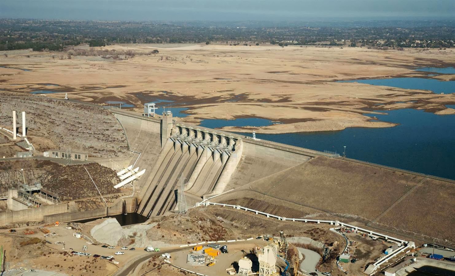
California's Folsom Lake on July 2011

California's Folsom Lake Febuary 2014

California is experiencing its worst drought since record-keeping began in the mid 19th century, and scientists say this may be just the beginning. B. Lynn Ingram, a paleoclimatologist at the University of California at Berkeley, thinks that California needs to brace itself for a megadrought—one that could last for 200 years or more.

Greenland Ice Sheet is melting

Greenland is a vast store of ice. Nearly two miles thick at its center, it contains enough ice to raise the world’s sea levels by 23 feet. Satellite observations from July 25 2013 have revealed a dramatic and unprecedented level of ice melt in Greenland. Scientists say an estimated 97 percent of Greenland's ice sheet surface, from its thin, low-lying coastal edges to its center, thawed at some point in mid-July.

The Greenland Ice Sheet is Starting to melt. 

Reports coming in over the past decade show that the vast two mile high Greenland ice sheet is starting to melt. 
Thousands of melt ponds appearing on Greenland's ice sheet.


One melt pond the size of a lake, draining off to the ocean. There are thousands of these.
  Unfortunately, we may be too late to avoid a catastrophic global sea level rise. Under the current climate change effect, the Greenland ice sheet is sagging and deforming, filling with melt ponds and flows that flush through to its base, and slipping toward the ocean at an ever increasing pace.


 Research conducted by Arctic scientists shows that the ice sheet’s speed is increasing by a rate of about 2-3 percent per year. This speed of increase results in the disgorging of vast volumes of icebergs and melt waters into the North Atlantic. An average of about 500 cubic kilometers of icebergs and melt waters are now flowing into the ocean from Greenland alone. But with the pace of ice sheet melt and movement picking up, we are at the beginning of a very risky situation. The melt forces eventually reach a tipping point. The warmer water greatly softens the ice sheet. Floods of water flow out beneath the ice. Ice ponds grow into great lakes that may spill out both over top of the ice and underneath it. Large ice dams start to form. All this time ice motion and melt is accelerating. 
We will reach a tipping point and a surge of water and ice will enters the Atlantic ocean. Tsunamis of melt water bearing vast icebergs will contribute to sea level rise. And then the weather starts to get really nasty.
Extraordinarily Rapid Arctic Amplification.


 Despite the various reassurances, what we have seen over the past seven years or so is an extraordinarily rapid amplification of heat within the Arctic. Arctic sea ice continues its death spiral, hitting new record lows at various times at least once a year. Heat keeps funneling into the Arctic, resulting in heatwaves that bring 90 degree temperatures to Arctic Ocean shores during summer and unprecedented Alaskan melts during January. And we see periods during winter when sea ice goes through extended stretches of melt, as we did just last week in the region of Svalbard. One need only look at the temperature anomaly map for the last 30 days to know that something is dreadfully, dreadfully wrong with the Arctic:


 In the case of Greenland, the firing line for such events is the entire North Atlantic and, ultimately the Northern Hemisphere.


The human greenhouse gas effect is powerful. At the last ice age’s end, about 100 parts per million of additional CO2 was enough to end the last Ice Age. Today, CO2 has risen by 120 ppm and continues to rise by 2-3 parts per million each year even as other rising greenhouse gasses, primarily methane, add to this global warming. Because CO2 can remain in the atmosphere for a century or longer, its increasing concentration warms our climate over long periods of time. Through its absorption and emission of energy back onto Earth’s surface, increased atmospheric CO2 traps more heat in the climate system. 
Its warming effect, however, is amplified by positive feedback such as increased water vapor, reduced reflectivity of the ice, changes in cloud characteristics, and CO2 exchanges with the ocean and terrestrial ecosystems. The current pace and path of increased effect makes a bad situation worse as a CO2 rise to at least 480 ppm is predicted by mid-century. End of the century estimates come in at the catastrophic level of 800 ppm of CO2 and related greenhouse gasses.


Severe weather across the U.S. Southeast, Midwest, and East Coast February 21, 2014

A potent area of low pressure will intensify Thursday and Friday to produce lots of rain, snow, wind, and possibly some flying monkeys. Travelers are advised to avoid strangers on the yellow brick road.

A potent area of low pressure will intensify Thursday and Friday (February 20-21, 2014) to produce severe weather across the U.S. Southeast, Midwest, and the East Coast. The area of low pressure will also be responsible for producing blizzard conditions across parts of southern Minnesota and into north/central Iowa. Many spots will see over six inches of snow with winds gusting as high as 60 miles per hour (mph). Ahead of the front, temperatures are extremely warm. With a potent cold front pushing into an area seeing temperatures 10-20 degrees above average, you can bet that severe weather will likely develop. The biggest threat for severe weather today will occur across Mississippi, Alabama, Louisiana, Tennessee, Kentucky, Indiana, Illinois, and Ohio. By Friday, the threat shifts to the U.S. East Coast.


Jennifer Francis: "Understanding the Jetstream".

The extreme weather trend in the Northern Hemisphere is  recent, so the science that can explain what is happening is still tentative. The first hypothesis blamed a slowing of the northern hemisphere’s polar jet stream. That sounded plausible, and was published in 2012 in Geophysical Letters. The paper “Evidence linking Arctic amplification to extreme weather in mid-latitudes”, was written by Jennifer Francis of Rutgers University and Stephen Vavrus of the University of Wisconsin-Madison. I think that their theory will turn out to be right. That is not good news....


Jennifer Francis - Understanding the Jetstream

The fact is that the Arctic has been warming faster than anywhere else on Earth, and the difference in temperature between the Arctic and the temperate zone has been shrinking. Since that difference in temperature is what drives the jet stream, a lower difference means a slower jet stream.

A fast jet stream travels in a straight line around the planet from west to east, just like a mountain stream goes  straight downhill. A slower jet stream, however, meanders like a river crossing a plain. The loops it makes extend much further south and north than when it was moving fast.

In a big southerly loop, you will have Arctic air much further south than usual, while there will be relatively warm air from the temperate air mass in a northerly loop that extends up into the Arctic. Moreover, the slower-moving jet stream tends to get “stuck”, so that a given kind of weather—snow or rain or heat—will stay longer over the same area.

Hence the “polar-vortex” winter in North America this year, the record snowfalls in Japan in 2012 and again this winter, the lethal heat waves in the eastern U.S. in 2012—and the floods in Britain this winter.

“They’ve been pummelled by storm after storm this winter [in Britain],” said Francis at the American Association for the Advancement of Science conference in Chicago last week. “It’s been amazing what’s going on, and it’s because the pattern this winter has been stuck in one place ever since early December.” There’s no particular reason to think that it will move on soon, either.

Climate Change 2013: Greenland Ice Sheet & Northern Polar Jet Stream - Peter Sinclair

Enormous chunks of ice melting into the sea.


The video comes from photographer James Balog's film, . The two guys on the bluff at the beginning are part of Balog's Extreme Ice Survey team, which maintains scores of time-lapse cameras overlooking glaciers in Greenland, Iceland, Alaska, Canada, the Rockies and the Himalayas. During daylight hours, they watch and record. Then they share what they see with scientists and National Geographic.

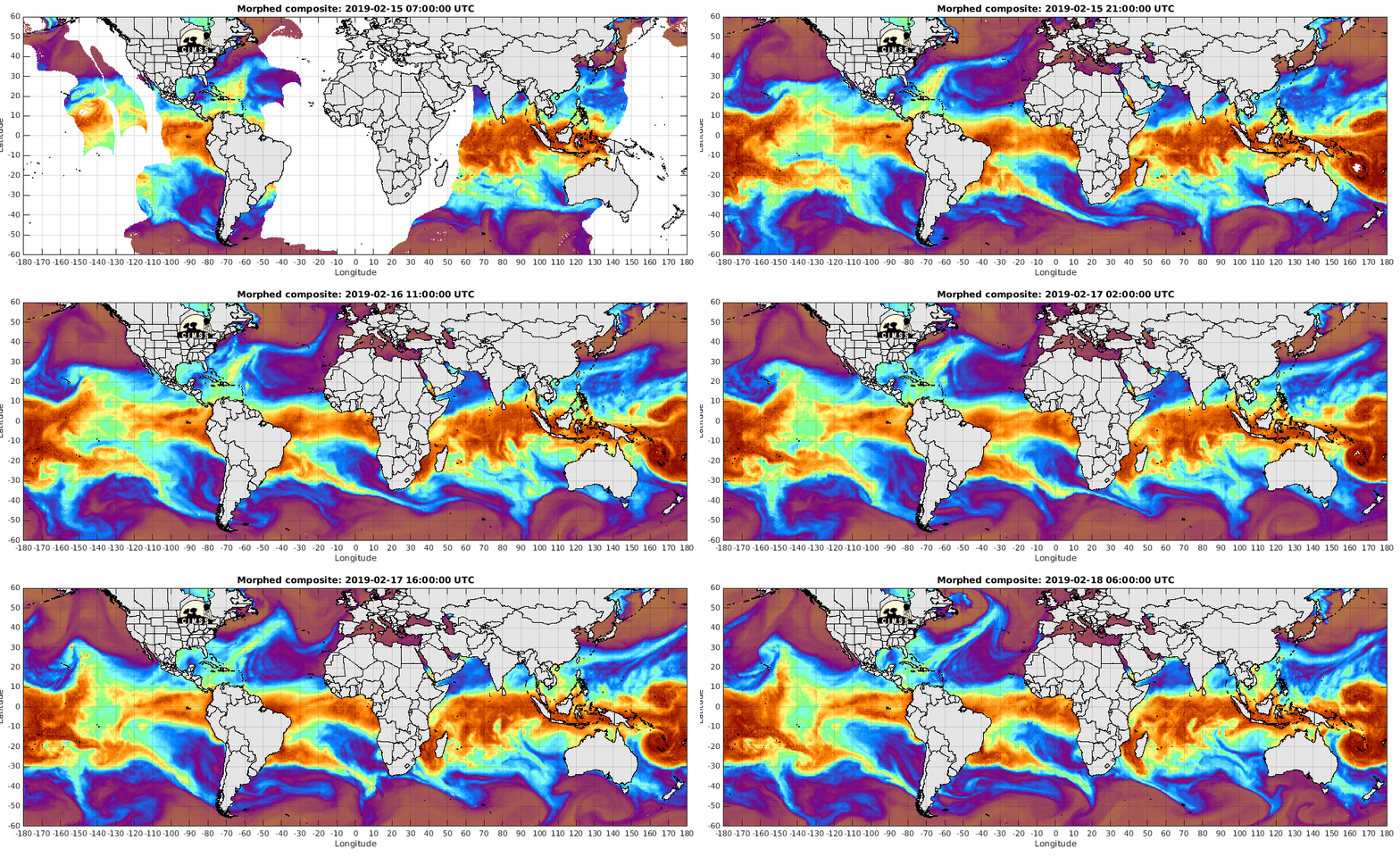
Total Precipitable Water - Global

SSMI/SSMIS/TMI-derived Total Precipitable Water - Global

Current time: Mon, 17 Feb 2014 05:36:04 GMT

Sat 2

Helicopter flyover Thames Valley (Flooding in England).

Birds-Eye View Of River Thames As It Reaches Highest Level Since 1883. Video recorded February 10, 2014. The UK is experiencing its most exceptional period of rainfall in 248 years, with hundreds of flood alert warnings covering much of the country and hundreds of homes left inundated.

Another major storm in the Atlantic expected to develop hurricane force winds.

Another major winter storm brewing in the North Atlantic. This is the latest snowstorm to blanket New England in a foot of snow. Picking up speed and moving east to Europe and possibly Great  Britain.
An animated loop of today's visible satellite imagery combined with lightning density has been created, and it shows this rapidly intensifying system with thunderstorms developing ahead of the strong cold front : http://go.usa.gov/BVJm
"Rapidly intensifying low pressure off the mid-Atlantic coast is expected to develop hurricane force winds within the next 24 hours in the W Atlantic. The top portion of the image contains segments of the OPC 24-Hour W Atlantic Surface and Wind/Wave forecasts produced earlier today. A composite forecast of the low track through 120 hours from today's 12Z OPC charts is in the lower left, and a part of the 18Z Atlantic Surface Analysis is in the lower right.


The forecast central pressure of the low center at 24 hours is 965 hPa with winds in the south quadrant up to 65 kt. OPC is forecasting significant wave heights up to 36 ft in the vicinity of the hurricane force winds. Full versions of these charts are available on the main OPC website:
 http://go.usa.gov/ByF3  ~ NOAA NWS Ocean Prediction Center


More rain expected in the UK : Update on England Floods

I learned a new word today. "Extratropical cyclone". 


The Environment Agency has issued 24 severe flood warnings.
The latest warnings are for various places along the south coast of England.

The Met Office said that following the heavy rain that had fallen in many places during the day, it expected "potentially damaging" severe gales in southern England during the evening and into Saturday morning.


BBC Weather's Peter Gibbs said that with gusts of up to 80 mph likely, there was a danger of high tides bringing fresh coastal flooding.


About 2,200 armed forces personnel - regulars and reserves - are helping the flood relief effort and a further 3,000 are on standby to respond within two hours. Flood defenses in Gloucester are succeeding in holding back the water, according to the Environment Agency.  Council staff in Hampshire have been moved from their "normal day jobs" to help the flood relief effort. The prime minister said UK businesses were offering "free help" to those affected by the flooding. Major supermarkets are providing supplies such as waders, food parcels, batteries and torches.


Police have appealed to drivers across Northern Ireland to take extra care as rain and snow disrupt travel.

Heavy rain brings widespread flooding to England.

After weeks of above average rainfall and a series of heavy winter storms that had the UK in its cross-hairs, the aftermath is what one would see after a hurricane: major damage to infrastructure, loss of thousands of cars, and property damages in the billions due to flooding. Most of southern England is in a high level flood alert, with more rain on the way. The severe weather has caused disruption for commuters which could take months to resolve, with thousands of acres of land affected, and residents who have been flooded for weeks. The situation has reached a critical level. 


The Thames Barrier is a series of giant metal gates downstream of central London that can be closed against tidal surges. The Thames Barrier has closed almost as many times in the past six weeks as in the whole of the 1990's. The  wettest period of weather for a century has seen the barrier closed a record 29 times since the beginning of the year, compared with 35 times in the decade of the 1990's. It is what protects London from tidal flooding. With thousands of homes along the Thames  threatened by flood water, the emergency work to prevent flooding continues, including the distribution of tens of thousands more sandbags by the Royal Marines. As the waters continued to rise, some residents tried to help others who want to leave, while some were concerned how they would get to work today, with cars trapped and the rail line to London closed.


England has had its wettest January since 1766. Its southwest coast has been battered repeatedly by storms, and a large area of the low-lying Somerset Levels in the southwest has been under water for more than a month. The disaster has sparked a political storm. Prime Minister David Cameron's Conservative-led government is facing criticism for allegedly failing to dredge rivers and take other flood-prevention measures.
Cameron and Deputy Prime Minister Nick Clegg visited flood-hit areas Monday as the government struggled to take charge of the crisis. Cameron denied that the government had been slow to respond.
"We have been dealing with it from the very moment it started," he said. "Where money was needed, we provided more money. Where military was needed, I made sure the military was deployed."


As of 7.52am GMT, Fire crews in Surrey have rescued 150 people over the last 24 hours as police warn that residents in around 2,500 homes are at risk. Chief superintendent Matt Twist, borough commander for the flooded areas in north Surrey, described the floods as an “extremely challenging situation”.


11-metre waves are also pounding the coast of  Ireland, Spain, Portugal and France causing extensive damage.